 |
 |
 |
 |
 |
- Welcome
- Search TravelJharkhand.com
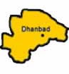 Dhanbad district situated in the state of Jharkhand is a mining and industrial town. It is the largest city in Jharkhand and is famous for its coal fields. The Dhanbad lies between 23.37'3" N and 24.4' N latitude and between 86.6'30" E and 86.50' E longitude. Dhanbad lies 168 km from Ranchi and 171 kilometers from Jamshedpur, and is bounded by Giridih on the west, Bokaro on the north, by Giridih and Dumka and on the east and south by Purulia district of West Bengal.
Dhanbad is also known as the 'Coal capital' and 'City of Coal' due to the rich deposits present in the district. Its economy completely depends upon coal mining and related industries. The companies which have played a major role in the development of Dhanbad are Tata Steel, Indian Iron and Steel Company Bharat Coking Coal Ltd. etc.
Dhanbad has a rich history of growth, urbanisation and migration of people. The early history of the Dhanbad is shrouded in mystery. Details of even later periods are difficult to trace. The present district used to be a part of Manbhum. In the Settlement Report for Manbhum (1928) it was stated that no rock inscriptions, copper plates or old coins were discovered and not a single document of copper plate or palm leaf was found, during the Survey and Settlement operations. The oldest authentic documents produced were all on paper and barely even a hundred years old. Dhanbad was in Manbhum district from 1928 up to 1956. However, on 24 October 1956, Dhanbad was declared a District on the Recommendation of the States Reorganization Commission vide notification 1911. And from 1956 to 14 November 2000 it was under Bihar. At present it is in Jharkhand, after the creation of state on 15 November 2000.
Dhanbad is about 500-1000 feet above sea level. Its soil is mostly lateritic in nature. The rivers flowing through Dhanbad are Damodar, Mayurakshi, barakar, Koyal, sankh, Son, Auranga, More, Karo, Bansloi, South Koel, Kharkai, Swarna Rekha etc. Damodar which is the most important river of the Chotanagpur plateau rises in Palamu and flows eastward between the plateaus of Ranchi and Hazaribag. It is joined by the Bokaro, the Konar and the Barakar rivers. Charak Pathar, Chati Gobindpur, Gopalpur, Jhinjhipahari, Meva, Panrra, Chark - Khurd, Topchanchi, Maithon, Panchet, Jamadoba are the attractions in and around Dhanbad. Many technical institutes, collages, and research institutes also form the attraction of the city.
Important Institutes, Public Sector Undertakings, Govt. Offices and Private Sector units in Dhanbad district include Central Mining Research Institute, Central Fuel Research Institute, Indian School of Mines, Director General of Mines Safety, Bharat Coking Coal Limited, Eastern Coalfields Limited Mugma Area, Damodar Valley Corporation, Fertilizer Corporation of India Limited, Hindustan Zinc Limited, Project & Development India Limited, Mineral Area Development Authority, Divisional Railway Office (East-Central Railway), Central Industrial Security Force, Patliputra Medical College, Bihar Institute of Technology, TISCO, IISCO, CCWO, CMPF etc.
In Dhanbad temperature ranges from maximum 39 to 20°C during summer, and minimum 20 to 2°C during winter.
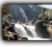
Places of interest in and around Dhanbad include Maithon (Boating is available here, 45 km. from station), Kalyaneshwari temple, Topchanchi Lake (37 km from Dhanbad railway station), Bhatinda Falls (14 km from Dhanbad railway station, Panra, Shakti Mandir, Lillori-sthan Mandir (19 km from Dhanbad), Chark- khurd, Gopalpur, Panchet etc.
Read more >> Dhanbad - At a Glance
 The movement for a separate state of Jharkhand is an odyssey spread over a century which is traced back to the early 1900s, when Jaipal Singh, an Indian Hockey captain and Olympian, suggested the idea of a separate state consisting of the southern districts of Bihar. The idea did not become a reality, however, until August 2, 2000, when the Parliament of India passed the Bihar Reorganization Bill to create the state of Jharkhand, carving 18 districts .......
 Jharkhand has a population of 26.90 million, consisting of 13.86 million males and 13.04 million females. Like most of our states Jharkhand is also a melting pot where people from different parts of the country have come and settled down. The population consists of 28% tribes, 12% Scheduled Castes and 60% others. There are 32 different tribal communities, major one being Santhals, Oraons, Mundas and Hos. Other tribes include Asur, Baiga, Banjara, Bathudi, Bedia, Binjhia, ......
Jharkhand's culture is rich and diverse and as a result unique in its very own way. Archeaologists have unearthed pre-Harappan pottery, pre-historic cave paintings and rock-art from various parts of Jharkhand. That hint at ancient, cultured civilizations inhabiting these parts. The intricate woodwork, the pitkar paintings, tribal ornaments, stone carvings, dolls and figurines, masks and baskets, all are pointing towards the cultural wealth of Jharkhand existed even before the ........
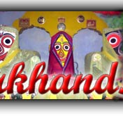
Various religious fairs and festivals celebrated in Jharkhand. Barura Sharif, Belgada Mela Simaria, Bhadli Mela Itkhori, Chatra Mela, Kolhaiya Mela Chatra, Kolhua Mela Hunterganj, Kunda Mela Pratappur, Kundri Mela Chatra, Lawalong Mela, Rabda Sharif, Sangat and Tutilawa Mela Simaria are some of the prominent fairs and festivals of Jharkhand. Specific festivals of the tribes are Karma, Manda, Sarhul, Jani shikar, Bandna etc. Sarhul is the spring festival where Sal tree .......
Jharkhand's culture is rich and diverse and as a result unique in its very own way. Archeaologists have unearthed pre-Harappan pottery, pre-historic cave paintings and rock-art from various parts of Jharkhand. That hint at ancient, cultured civilizations inhabiting these parts. The intricate woodwork, the pitkar paintings, tribal ornaments, stone carvings, dolls and figurines, masks and baskets, all are pointing towards the cultural wealth of Jharkhand existed even before the ........
Jharkhand's culture is rich and diverse and as a result unique in its very own way. Archeaologists have unearthed pre-Harappan pottery, pre-historic cave paintings and rock-art from various parts of Jharkhand. That hint at ancient, cultured civilizations inhabiting these parts. The intricate woodwork, the pitkar paintings, tribal ornaments, stone carvings, dolls and figurines, masks and baskets, all are pointing towards the cultural wealth of Jharkhand existed even before the ........
Jharkhand has a population of 26.90 million, consisting of 13.86 million males and 13.04 million females. Like most of our states Jharkhand is also a melting pot where people from different parts of the country have come and settled down. The population consists of 28% tribes, 12% Scheduled Castes and 60% others. There are 32 different tribal communities, major one being Santhals, Oraons, Mundas and Hos. Other tribes include Asur, Baiga, Banjara, Bathudi, Bedia, Binjhia, ......
Jharkhand's culture is rich and diverse and as a result unique in its very own way. Archeaologists have unearthed pre-Harappan pottery, pre-historic cave paintings and rock-art from various parts of Jharkhand. That hint at ancient, cultured civilizations inhabiting these parts. The intricate woodwork, the pitkar paintings, tribal ornaments, stone carvings, dolls and figurines, masks and baskets, all are pointing towards the cultural wealth of Jharkhand existed even before the ........
Various religious fairs and festivals celebrated in Jharkhand. Barura Sharif, Belgada Mela Simaria, Bhadli Mela Itkhori, Chatra Mela, Kolhaiya Mela Chatra, Kolhua Mela Hunterganj, Kunda Mela Pratappur, Kundri Mela Chatra, Lawalong Mela, Rabda Sharif, Sangat and Tutilawa Mela Simaria are some of the prominent fairs and festivals of Jharkhand. Specific festivals of the tribes are Karma, Manda, Sarhul, Jani shikar, Bandna etc. Sarhul is the spring festival where Sal tree .......
Jharkhand's culture is rich and diverse and as a result unique in its very own way. Archeaologists have unearthed pre-Harappan pottery, pre-historic cave paintings and rock-art from various parts of Jharkhand. That hint at ancient, cultured civilizations inhabiting these parts. The intricate woodwork, the pitkar paintings, tribal ornaments, stone carvings, dolls and figurines, masks and baskets, all are pointing towards the cultural wealth of Jharkhand existed even before the ........
Jharkhand's culture is rich and diverse and as a result unique in its very own way. Archeaologists have unearthed pre-Harappan pottery, pre-historic cave paintings and rock-art from various parts of Jharkhand. That hint at ancient, cultured civilizations inhabiting these parts. The intricate woodwork, the pitkar paintings, tribal ornaments, stone carvings, dolls and figurines, masks and baskets, all are pointing towards the cultural wealth of Jharkhand existed even before the ........Home Must see spots Hotels Travel Agencies Advertise with us Contact Feed Back COPYRIGHT © 2008 TravelJharkhand.com | | Designed and Developed by GIGISOFT Solutions |