 |
 |
 |
 |
 |
- Welcome
- Search TravelJharkhand.com
 Ranchi, Capital of Jharkhand is one of the oldest districts in Jharkhand. Ranchi is also called as city of Water falls and lakes. Earlier the name of the district was Lohardaga. The old district had come into existence after the creation of the non-regulation South – West frontier as a result of the Kol rising in 1831-32. The name of the district was changed in 1899 from Lohardaga to Ranchi after the name of a small village now comprised within the headquarters station.
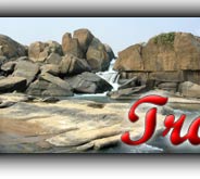
The name Ranchi comes from "archi" an Oraon/Kurukh word for the farmer's "baton" in use while ploughing. Before that up to 1927, this place (Ranchi) was known as Rachi. The area was an agricultural locality, in between Hinoo & Harmoo River was a better known place for its military base and garrison. The present Purani Ranchi was originally known as the village Archi. Ranchi was the centre of the Jharkhand movement for a separate state for the tribal regions of South Bihar, northern Orissa, Western West Bengal and the present eastern Chhattisgarh. Subarnarekha River flows by the side of the city. Ranchi is a city of many Falls and lakes.
Administrative Setup in Ranchi is divided into Ranchi, Khunti and Bundu subdivisions and each subdivision is further divided into blocks, panchayats and villages. Total number of Educational Blocks in Ranchi is 24. Kanke tops the list of blocks having highest literacy rate and Arki is the block with least literacy rate. Ranchi has a large ST population (45%). It has 20 blocks consisting of 2,110 villages. The district of Ranchi is predominantly rural with only 16.32 % of the total population residing in six urban centres.As of 2001 India census, Ranchi had a population of 846,454. Males constitute 53% of the population and females 47%. Ranchi has an average literacy rate of 74%, higher than the national average of 59.5%: male literacy is 80%, and female literacy is 68%. In Ranchi, 13% of the population is under 6 years of age.
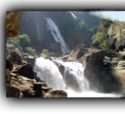
Geographically, Ranchi is located on southern part of the Chota Nagpur plateau which forms the eastern edge of the Deccan plateau system. The area surrounding Ranchi has been endowed with natural attractions. Main tourist Attractions in Ranchi include water falls viz Hundru Falls, Jonha Falls, Dassam falls, Panch Gagh falls, Hirni falls etc and Gonda Hill, Rock Garden, Machli Ghar, Muta Crocodile breeding centre, Birsa Jaivik Udyan, Tagore Hill, McCluskigunj, Tribal Research Institute and Museum etc. Ranchi has a hilly topography and its combination with dense tropical forests ensures that it enjoys a comparatively moderate climate compared to the rest of the state.
Ranchi has a sub-tropical climate. Temperature ranges from maximum 39 to 20°C during summer, and minimum 20 to 2°C during winter. The annual rainfall is about 1530 mm. From June to September the rainfall level is about 1,100 mm.
Earlier the name of the district was Lohardaga. The old district had come into existence after the creation of the non-regulation South – West frontier as a result of the Kol rising in 1831-32. The name of the district was changed in 1899 from Lohardaga to Ranchi after the name of a small village now comprised within the headquarters station. In ancient times the tract which corresponds to the district of Ranchi and the neighbouring parganas was in the undisturbed possession of Munda and Oraon tribes and was known to Aryans as Jharkhand or the 'forest territory'. The entire tract was presumably beyond the pale of the direct Hindu influence in ancient India. However, Jarasandh, the mighty emperor of Rajgriha in the Mahabharat period might have exercised some kind of loose supervision over the area........
Read more >> History of ranchi
Read more >> Ranchi district - At a Glance
Read more >> Administrative Setup of Ranchi
Read more >> Ranchi District Population ( Census 2001 )
 The movement for a separate state of Jharkhand is an odyssey spread over a century which is traced back to the early 1900s, when Jaipal Singh, an Indian Hockey captain and Olympian, suggested the idea of a separate state consisting of the southern districts of Bihar. The idea did not become a reality, however, until August 2, 2000, when the Parliament of India passed the Bihar Reorganization Bill to create the state of Jharkhand, carving 18 districts .......
 Jharkhand has a population of 26.90 million, consisting of 13.86 million males and 13.04 million females. Like most of our states Jharkhand is also a melting pot where people from different parts of the country have come and settled down. The population consists of 28% tribes, 12% Scheduled Castes and 60% others. There are 32 different tribal communities, major one being Santhals, Oraons, Mundas and Hos. Other tribes include Asur, Baiga, Banjara, Bathudi, Bedia, Binjhia, ......
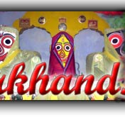
Jharkhand's culture is rich and diverse and as a result unique in its very own way. Archeaologists have unearthed pre-Harappan pottery, pre-historic cave paintings and rock-art from various parts of Jharkhand. That hint at ancient, cultured civilizations inhabiting these parts. The intricate woodwork, the pitkar paintings, tribal ornaments, stone carvings, dolls and figurines, masks and baskets, all are pointing towards the cultural wealth of Jharkhand existed even before the ........
Various religious fairs and festivals celebrated in Jharkhand. Barura Sharif, Belgada Mela Simaria, Bhadli Mela Itkhori, Chatra Mela, Kolhaiya Mela Chatra, Kolhua Mela Hunterganj, Kunda Mela Pratappur, Kundri Mela Chatra, Lawalong Mela, Rabda Sharif, Sangat and Tutilawa Mela Simaria are some of the prominent fairs and festivals of Jharkhand. Specific festivals of the tribes are Karma, Manda, Sarhul, Jani shikar, Bandna etc. Sarhul is the spring festival where Sal tree .......
Jharkhand's culture is rich and diverse and as a result unique in its very own way. Archeaologists have unearthed pre-Harappan pottery, pre-historic cave paintings and rock-art from various parts of Jharkhand. That hint at ancient, cultured civilizations inhabiting these parts. The intricate woodwork, the pitkar paintings, tribal ornaments, stone carvings, dolls and figurines, masks and baskets, all are pointing towards the cultural wealth of Jharkhand existed even before the ........
Jharkhand's culture is rich and diverse and as a result unique in its very own way. Archeaologists have unearthed pre-Harappan pottery, pre-historic cave paintings and rock-art from various parts of Jharkhand. That hint at ancient, cultured civilizations inhabiting these parts. The intricate woodwork, the pitkar paintings, tribal ornaments, stone carvings, dolls and figurines, masks and baskets, all are pointing towards the cultural wealth of Jharkhand existed even before the ........
Jharkhand has a population of 26.90 million, consisting of 13.86 million males and 13.04 million females. Like most of our states Jharkhand is also a melting pot where people from different parts of the country have come and settled down. The population consists of 28% tribes, 12% Scheduled Castes and 60% others. There are 32 different tribal communities, major one being Santhals, Oraons, Mundas and Hos. Other tribes include Asur, Baiga, Banjara, Bathudi, Bedia, Binjhia, ......
Jharkhand's culture is rich and diverse and as a result unique in its very own way. Archeaologists have unearthed pre-Harappan pottery, pre-historic cave paintings and rock-art from various parts of Jharkhand. That hint at ancient, cultured civilizations inhabiting these parts. The intricate woodwork, the pitkar paintings, tribal ornaments, stone carvings, dolls and figurines, masks and baskets, all are pointing towards the cultural wealth of Jharkhand existed even before the ........
Various religious fairs and festivals celebrated in Jharkhand. Barura Sharif, Belgada Mela Simaria, Bhadli Mela Itkhori, Chatra Mela, Kolhaiya Mela Chatra, Kolhua Mela Hunterganj, Kunda Mela Pratappur, Kundri Mela Chatra, Lawalong Mela, Rabda Sharif, Sangat and Tutilawa Mela Simaria are some of the prominent fairs and festivals of Jharkhand. Specific festivals of the tribes are Karma, Manda, Sarhul, Jani shikar, Bandna etc. Sarhul is the spring festival where Sal tree .......
Jharkhand's culture is rich and diverse and as a result unique in its very own way. Archeaologists have unearthed pre-Harappan pottery, pre-historic cave paintings and rock-art from various parts of Jharkhand. That hint at ancient, cultured civilizations inhabiting these parts. The intricate woodwork, the pitkar paintings, tribal ornaments, stone carvings, dolls and figurines, masks and baskets, all are pointing towards the cultural wealth of Jharkhand existed even before the ........
Jharkhand's culture is rich and diverse and as a result unique in its very own way. Archeaologists have unearthed pre-Harappan pottery, pre-historic cave paintings and rock-art from various parts of Jharkhand. That hint at ancient, cultured civilizations inhabiting these parts. The intricate woodwork, the pitkar paintings, tribal ornaments, stone carvings, dolls and figurines, masks and baskets, all are pointing towards the cultural wealth of Jharkhand existed even before the ........Home Must see spots Hotels Travel Agencies Advertise with us Contact Feed Back COPYRIGHT © 2008 TravelJharkhand.com | | Designed and Developed by GIGISOFT Solutions |